What are Contour Lines on the Topographic Maps?
- March 20, 2020
- 0
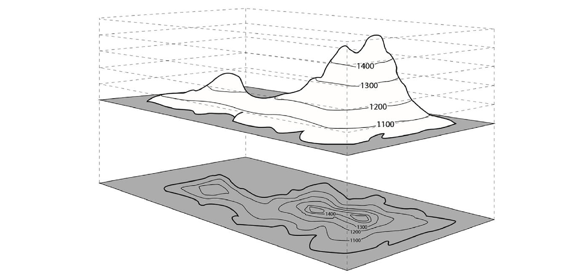
Topography is the study of geographical features on a landscape. A map with contour lines on it is called a topographic map. Contour lines mark points of equal elevation on a map. If you were to walk the path of a contour line in real life, you would remain at the same elevation the whole hike. When contour lines spaced close together, this would indicate steep terrain, while lines spaced far apart, this would indicate a gentler slope.
𝗪𝗵𝗮𝘁 𝗮𝗿𝗲 𝘁𝗵𝗲 𝘁𝘆𝗽𝗲𝘀 𝗼𝗳 𝗰𝗼𝗻𝘁𝗼𝘂𝗿 𝗹𝗶𝗻𝗲𝘀?
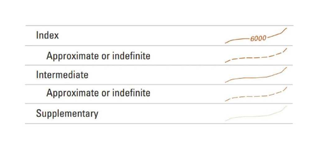 There are 3 types of contour lines you’ll see on a map: intermediate, index, and supplementary.
- Index lines are the thickest contour lines and are labeled with a number at one point along the line. This tells you the elevation above sea level.
- Intermediate lines are the thinner, more common, lines between the index lines. They usually don’t have a number label. Typically one index line occurs for every five intermediate lines.
- Supplementary lines appear as dotted lines, they are placed between regular contour lines to visualize small but important forms that regular contour lines are unable to show.
𝗛𝗼𝘄 𝘁𝗼 𝗿𝗲𝗮𝗱 𝗰𝗼𝗻𝘁𝗼𝘂𝗿 𝗹𝗶𝗻𝗲𝘀 𝗼𝗻 𝗮 𝗺𝗮𝗽?
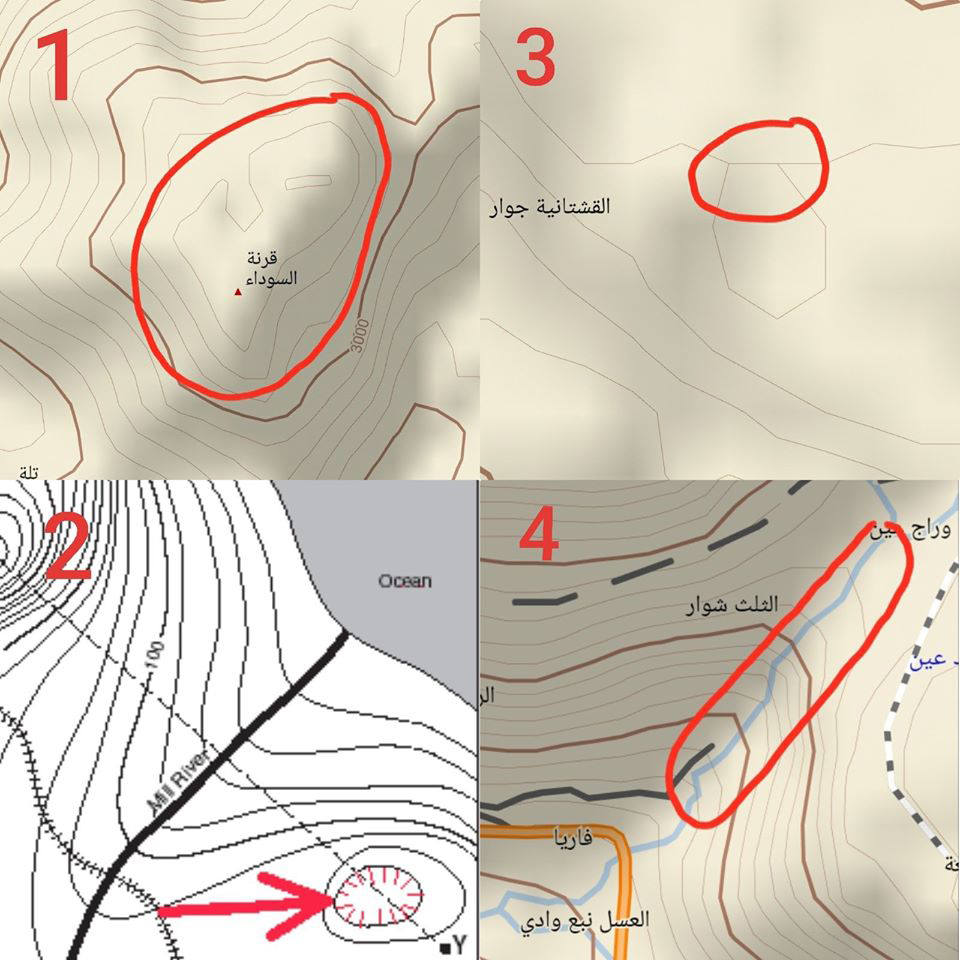
- 𝑷𝒆𝒂𝒌 𝑹𝒊𝒏𝒈: The ring at the center of several contour loops almost always represents a peak (highest elevation). This is known as the “Rule of O’s
- 𝑫𝒆𝒑𝒓𝒆𝒔𝒔𝒊𝒐𝒏 𝑹𝒊𝒏𝒈: Occasionally an inner ring indicates a depression (lowest elevation), which the map will show with a series of small tick marks pointing toward the center (called hachures).
- 𝑪𝒍𝒊𝒇𝒇: If you see two or more lines converge until they appear as a single line, this represents a cliff.
- 𝑽𝒂𝒍𝒍𝒆𝒚: When contour lines cross a valley or a stream, they make a sharp pointed V or U-shape. Rivers, of course, are represented by blue lines that will run through the center of the V-shape. You can also use a topographic map to determine the direction the river is flowing, the V-shape always points in the opposite direction that the water is flowing. This is called the “Rule of V’s”.